


Povazska - Gino Palace - 10/04/2019

HG74250
User
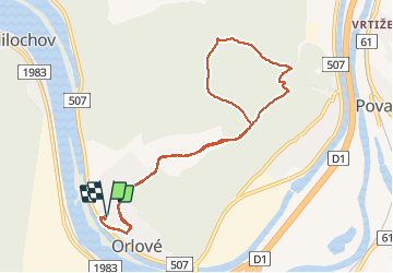

Length
8.9 km

Max alt
548 m

Uphill gradient
370 m
Km-Effort
13.8 km

Min alt
278 m

Downhill gradient
369 m
Boucle
Yes
Creation date :
2019-05-02 19:07:38.487
Updated on :
2020-01-04 17:15:10.794
1h00
Difficulty : Medium

FREE GPS app for hiking
 SityTrail
IGN / Geographical institutes
SityTrail World
The world is yours!
About
Trail Running of 8.9 km to be discovered at Region of Trenčín, Unknown, District of Považská Bystrica. This trail is proposed by HG74250.
Description
HG seul
Positioning
Country:
Slovakia
Region :
Region of Trenčín
Department/Province :
Unknown
Municipality :
District of Považská Bystrica
Location:
Považská Bystrica
Start:(Dec)
Start:(UTM)
312141 ; 5445162 (34U) N.
Comments
Trails nearby